Hurricane update

As of 1 am CDT, Dennis is now visible on the Key West Nexrad. It is off shore and just NE of Havana. All of the 00z models are in now and they are remarkably in agreement. It looks more and more likely that landfall will be somewhere in the western part of the Florida Panhandle or perhaps as far west as Gulfport Miss.
That could certainly change but I do not think it will change much. The steering currents are pretty stable.
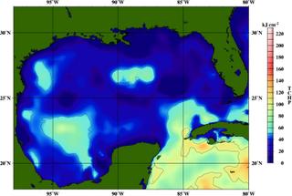
The big question is how much strength will Dennis regain. It has weakened considerably during the trek across Cuba. Yes the Gulf of Mexico is very warm, but the upper ocean heat content is not as favorable as it was over the Caribbean though.
Think of the heat content, not as how warm the water is but how deep is that warm water. Some interesting hurricane research has shown this to be a factor in tropical cyclone intensity. While atmospheric conditions favour strengthening, The heat content in the central Gulf is iffy. The image on this page is that of the tropical cyclone heat potential for Friday. Warm colors are where the tropical cyclone can extract more energy.
There is an area of higher heat near the coast of Alabama. That could cause some last minute intensification.
If the track models are right, we will escape any serious problems from Dennis here in the Valley with the worst conditions being in Franklin and Winston county. If it turns more north after landfall then that may change.
Still a cat 2/3 storm is better than a 4. A Category 4 would be seriously bad news for the coast.
I will update this discussion later on Saturday.
Later,
Dan


<< Home