09 July 2005

Dennis Back to Category 4

The recon aircraft sent back a central pressure of 941 mb just before 10 pm tonight. On the Saffir Simpson scale, that pressure would make Dennis a category 4 storm. The winds are not really up to cat 4 strength yet but they will do so shortly I think.

The difference between a cat 3 storm and a cat 4 storm hitting a coast line is quite dramatic. If it stays this strong or god forbid gets stronger, then the Alabama Gulf coast will be hit very hard. Likely worse than Ivan which weakened a bit as it hit land.
Something to remember that the force of the wind is not linear. When the wind speed doubles the force goes up by 4 not 2. That is why the increase in wind speed with a category 4 storm is so much more dangerous.
The storm surge will also be higher. Perhaps over 9 feet. The storm surge is a wall of water that will accompany the hurricane at and to the right of the eye. The low pressure in the storm and the winds actually will make the ocean level about 9 feet higher near the center of the storm.

The storm surge will hit the gulf coast very quickly. Not like a wave but the water will suddenly rise several feet in a matter of minutes. In hurricane past, the storm surge was the main killer in hurricanes, not the winds. Because of warnings and evacuations of susceptible areas, that is no longer true in most first world countries.

We will be doing extensive updates every 30 minutes starting at 6 am Sunday. Even if we do not get damage, We realize that many people have homes, friends and relatives on the coast.

Later,
Dan
Hurricane update


As of 1 am CDT, Dennis is now visible on the Key West Nexrad. It is off shore and just NE of Havana. All of the 00z models are in now and they are remarkably in agreement. It looks more and more likely that landfall will be somewhere in the western part of the Florida Panhandle or perhaps as far west as Gulfport Miss.

That could certainly change but I do not think it will change much. The steering currents are pretty stable.

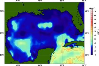
The big question is how much strength will Dennis regain. It has weakened considerably during the trek across Cuba. Yes the Gulf of Mexico is very warm, but the upper ocean heat content is not as favorable as it was over the Caribbean though.

Think of the heat content, not as how warm the water is but how deep is that warm water. Some interesting hurricane research has shown this to be a factor in tropical cyclone intensity. While atmospheric conditions favour strengthening, The heat content in the central Gulf is iffy. The image on this page is that of the tropical cyclone heat potential for Friday. Warm colors are where the tropical cyclone can extract more energy.

There is an area of higher heat near the coast of Alabama. That could cause some last minute intensification.

If the track models are right, we will escape any serious problems from Dennis here in the Valley with the worst conditions being in Franklin and Winston county. If it turns more north after landfall then that may change.

Still a cat 2/3 storm is better than a 4. A Category 4 would be seriously bad news for the coast.

I will update this discussion later on Saturday.

Later,
Dan

08 July 2005

Hurricane Forecasting

Someone said a few years back that if weather satellites could only be used for tracking hurricanes, they would still be worth their cost many times over. It is certainly true. I myself cannot imagine what it was like to try and forecast these things before real time satellite imagery.

Meteorologists have developed a technique for ascertaining the strength of a tropical storm using only satellite imagery. This technique works quite well and is used frequently when recon. aircraft are not available or the storm is still out of range. If you read the hurricane discussions on the Tropical Prediction Center web site, they are mentioned as T numbers.

Some more interesting research into hurricanes has to do with what is called tropical cyclone heat content. Why do some hurricanes weaken before land fall and others get much stronger suddenly. This happens many times when no other factors appear to be involved.

It might very well have to do with the depth of the warm water. Sometimes the warm water is very deep and the hurricane has a lot of energy to draw on. If a storm passes over an area of high heat content just before land fall, then a rapid strengthening is possible.

Looking at some late data tonight, it appears that Dennis may weaken in the Gulf because of lower upper ocean heat content. However, there is an area of high heat content just off the Mississippi coast and if the storm heads for New Orleans or even Mobile, it could pass over this and strengthen just before land fall. Something I will be watching closely this weekend.

One last thing on my mind this morning.

In the last few years the evacuations for hurricanes have been too great in my opinion. Floyd was an example of this. Tell people to evacuate and nothing happens and the next time they may not go. When it does hit, people should be allowed to get back to their homes and salvage what is available.

I've heard quite a few people tell me that they will ride out the storm next time because when it is over they cannot be kept from going back in if they are already there. Not sure I blame them.

I am a weather forecaster and it is not my job to tell people they must leave their homes. You will NEVER hear me do so. I will suggest a course of action based on expected weather conditions though, and when a cat 4 is coming...it is smart advice to get out.

Later,
Dan

06 July 2005

Windy night in the Big Easy

Tropical storm Cindy is passing right over New Orleans as I type this. The lake front aiport is getting gusts to 60 mph in torrential rains. The main airport has gusts to 52 mph. Cindy is a tiny storm though with winds a hundred miles away reported as CALM! Camille was a similar storm. Much much stronger of course. Camille's winds were 200 mph.

Dennis is next in line and if the long range model guidance is right, New Orleans has a much bigger problem on it's hands. This far out a computer projection is cause for interest, nothing more.

Make no mistake about it though. N.O. is living on borrowed time. The city is already below sea level and believe me the sea knows about it. The pumping of oil and water from beneath the ground and the compaction of the Mississippi river sediment that the city was built on bring it a little lower every year.

Every time I visit the French Quarter, I look at those old historic buildings as if I may never see them again. They will be gone some day.

I guess you cannot just up and move a whole city..Well until mother nature does it for you, and that she will eventually do to the big easy. Tonight is just a warning from the sea that it will win eventually.

It ALWAYS does.

Later,
Dan

05 July 2005

Here's to a great city


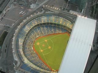
I had not been to Toronto for many years until last month. I waited too long. Canada itself is one of the most beautiful places on earth with endless prairies across the plains and and the most spectacular mountain scenery in North America. It's largest city is a real treat though. No wonderful scenery to speak of but the CN Tower rising majestically above downtown is a must visit. From the top observation deck we looked down into the opened domed Rogers Center where the Blue Jays were playing. The view out across Lake Ontario was beautiful at sunset.

Toronto is full of immigrants. A sure thing necessary for a vibrant city. Cultures of all kinds and food restaurants with fresh food native to those cultures is readily at hand. Not to mention a Tim Hortons donut shop on every corner.
(Until you have gone into a Tim Hortons and got a donut and their famous coffee on a night with a meter of snow on the ground and the temp at -10c then you haven't really been to Canada. (I HAVE!)

Toronto has a fabulous city park. The Toronto Islands. Reached by a passenger ferry, it is a beautiful park. It has beaches and small carnival rides along with a beautiful landscaped park path and fountains. I wanted to visit the clothing optional beach but my wife said no. (Americans are so hung up on the clothes thing!)

If you get a chance, visit T.O. It's cool Canadian!
I will add some pics from my trip to this blog tomorrow.

Later,
Dan